Is Gothenburg a Walkable City? What to Expect on Foot
Yes, Gothenburg in Sweden is a walkable city, with a compact moat-ringed old town, a tram network for the gaps, and car-free islands in the archipelago. Here is what walking it is actually like.
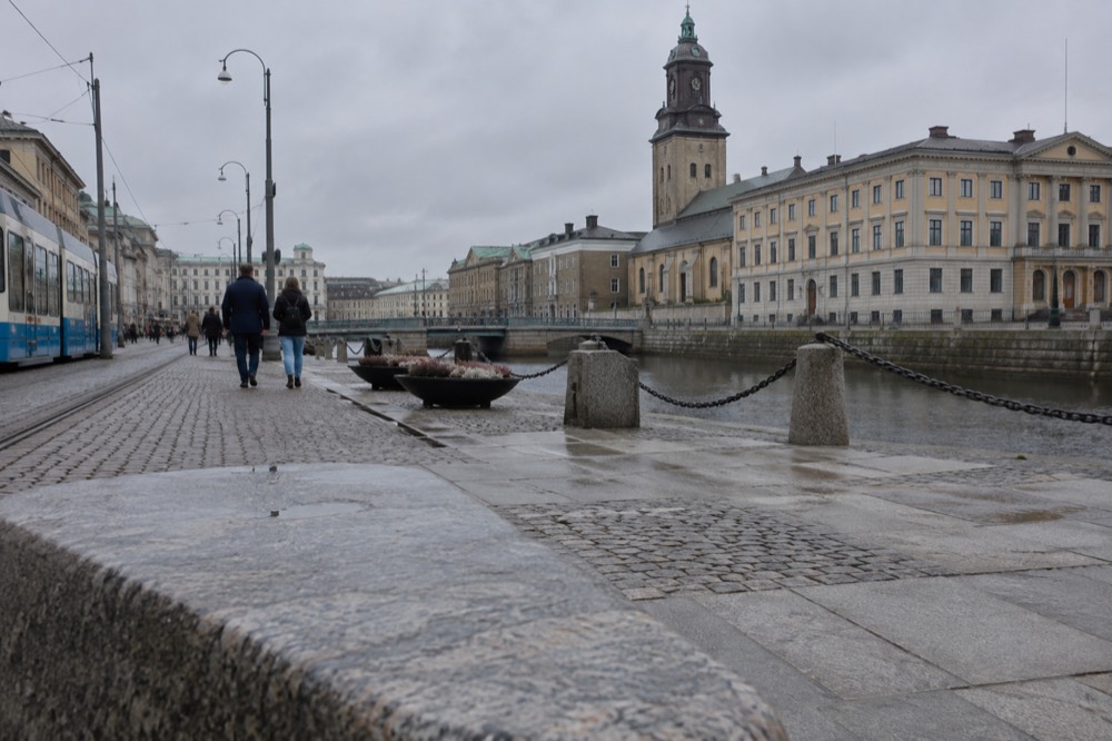
Gothenburg, Sweden's second city with 613,274 residents at the end of 2025, was built by Dutch engineers in the seventeenth century as a fortified trading town inside a moat. That plan still shapes the place. The old core, Inom Vallgraven, sits inside the line where the water defences used to run, and most of what a first-time visitor wants to see is packed into and around that footprint. The question "is Gothenburg a walkable city?" has a short answer, and this page works through it street by street: which parts reward walking, which parts fight you, and where the trams earn their keep.
Is Gothenburg a Walkable City?
Yes, Gothenburg is a genuinely walkable city, and its walkability comes from history rather than modern planning. The Dutch-engineered old town inside the former moat is compact enough to cross on foot, the cultural district at Götaplatsen sits at the top of the Avenyn boulevard within walking distance of the centre, and the tram network fills every gap. The 126 million tram journeys Göteborgs Spårvägar recorded in 2025 tell you how many locals never bother with a car.
That figure comes from Göteborgs Spårvägar, the municipal tram operator, and it is the strongest single piece of evidence for Gothenburg's walkability. A city where well over a third of a million people a day ride trams is a city built at a human scale, because trams only work when the places between the stops are worth walking through. Nobody rides a tram to a destination you drive to the door of.
The honest qualification is weather. Gothenburg records 912 mm of precipitation a year across 127 wet days, roughly one day in three, according to SMHI's 1991-2020 climate normals for the Göteborg A station. So the walking is real, but so is the umbrella. It is worth saying plainly: SMHI's own data does not support the cliche that Gothenburg is Sweden's rainiest city, and the institute's national maps put the precipitation maxima in the western highlands and the mountains, not here. The rain reputation is louder than the rain.
There is a second qualification that matters for anyone planning a trip around walking: the daylight. The US Naval Observatory's tables for Gothenburg's latitude of 57.7 degrees north give 18 hours 06 minutes of daylight on 21 June but only 6 hours 32 minutes on 21 December. A summer walking day can run from breakfast to midnight; a December one has to be spent like a budget, with the first hour after nine in the morning and the last before half past three in the afternoon. Walkability in this city is seasonal even when the streets are not.
How Compact Is the Gothenburg City Centre?
The walkable core of Gothenburg is the old town inside the former moat, Inom Vallgraven, together with the districts immediately around it: Nordstan and the Centralstation area to the north, Haga to the south-west, and the canal-side strips along the Göta älv. The Avenyn boulevard and Götaplatsen extend the walkable zone south, and the whole central belt is stitched together by tram lines rather than divided by arterial roads. A visitor staying anywhere central reaches most headline sights without setting foot on a bus.
Gothenburg Centralstation sits at the northern edge of this belt, next to Nordstan, one of Scandinavia's larger shopping centres. From there the city opens southward: the canal, the Kungsportsplatsen hub, then the main avenue, Avenyn, climbing to Götaplatsen, where the art museum, the concert hall and the city theatre stand around the Poseidon statue. Göteborgs konstmuseum, which charges 75 kr for a day ticket and is free for anyone under 20, anchors that end of the walk. The museum has its own future caveat worth knowing: it closes in 2028 for a rebuild and reopens in 2032, per its own site, so the building you can walk to today will not be the building a visitor walks to later in the decade.
The geography does the work. There is no river to cross repeatedly, no ring of motorways cutting the centre off from its waterfront, and the old moat line survives as canals and green strips rather than as a barrier. The city's own growth followed the tram lines outward, so the neighbourhoods worth visiting, Haga, Vasastan, Majorna, Linné and the Långgatorna strip, all grew up as tram suburbs. That means they are walkable internally and tram-connected to each other, which is the pattern that makes a city feel legible on foot rather than a sprawl you navigate district by district.
For orientation, the table below groups the central districts by what walking them is actually like:
| District | Character | Walking experience |
|---|---|---|
| Inom Vallgraven | The old town inside the moat line | Small blocks, stone and cobbles, the densest concentration of sights |
| Haga | Wooden landshövdingehus quarter, cafés | Gentle hill on the way to Skansen Kronan, rewarding on foot |
| Vasastan | Stone apartment streets, student cafés | Flat, residential, good for slow wandering |
| Avenyn and Götaplatsen | The boulevard and cultural district | A straight, legible spine walk from the centre |
| Linné and Långgatorna | Park, gardens and the bar strip | Flat, lively, tram lines running alongside |
| Majorna | Second-hand shops, working-class heritage | Longer stretch west, best combined with a tram ride |
One thing walking does better than any other mode here is the detail work. The painted wooden landshövdingehus, the red brick, the granite, the shipyard cranes across the river: these are street-level textures, and a window or a saddle is the wrong height for them. If you want the same story told from the water instead, the sightseeing fleet is the alternative, and the amphibious bus does both in one sitting.
Which Gothenburg Neighbourhoods Are Best on Foot?
Haga is the standout walking neighbourhood in Gothenburg, a preserved quarter of wooden landshövdingehus houses and cobbled lanes, and it climbs naturally toward Skansen Kronan, one of the city's hilltop forts. Vasastan and Linné offer flat, café-dense stone streets, Majorna stretches west as a second-hand and vintage quarter, and Inom Vallgraven is the compact historic core. All of them are tram-linked, so a walking day can be assembled from pieces rather than done as one long march.
Haga deserves its reputation. It was the first suburb outside the moat, and its low wooden houses, built in a style unique to Gothenburg where a stone ground floor carries timber storeys above, survived the modernisation that flattened much of the city centre. The walk up to Skansen Kronan from Haga is the classic short climb in Gothenburg, and the fort's hill gives one of the best roof-level views of the city. Göteborgs Stad's own heritage material treats the fort as a viewpoint, and the climb is short enough that it fits inside a coffee stop's detour.
West of the centre, Majorna runs toward the river and the archipelago tram terminus at Saltholmen. It is a longer walk than the centre, which is exactly why the tram exists. The network's western terminus is Saltholmen, so the second-hand quarter and the boat docks sit on the same tram corridor, and a day that starts in vintage shops can end on a ferry without ever changing mode of thinking, only vehicle. The district reads as working-class Gothenburg: granite, painted wood, and a harbour identity that the centre's shopping streets have polished away.
The boulevard end is Avenyn, running straight from Kungsportsplatsen to Götaplatsen. It is the least charming of the central walks and the most useful, because it is the spine everything else hangs from. Once you have walked Avenyn once, the city's geography stops being a map and becomes a memory, and every other district is a tram ride measured from a point you already know.
None of these districts demands a car, and all of them punish one: parking is scarce, the streets were drawn for trams and feet, and the distances between cafés are measured in minutes. For a fuller verdict on the city as a destination, the is Gothenburg worth visiting for tourists answer makes the broader case, and the what Gothenburg is known for piece lists what those walks actually pass.
Where Does Walking Get Hard in Gothenburg?
Walking in Gothenburg gets hard in three places: crossing to Hisingen and the northern waterfront districts such as Lindholmen, reaching the outer areas like Angered or Mölndal at the tram network's ends, and any island-hopping beyond the southern archipelago ferry terminals. The centre is compact, but the city as a whole spans from Mölndal in the south to Angered in the north and across the bridge to Hisingen, per Göteborgs Spårvägar's network description, and that scale belongs to the trams.
Hisingen is the big one. The river Göta älv splits the city, and while the bridges and commuter ferries connect it, Lindholmen's waterfront and the old shipyard districts are a different walking world from the south-bank centre. The crossing itself is part of the experience, and the river's north bank is where the cranes and the working harbour live, but it is a ride, not a stroll. Anyone planning a day that mixes both banks should budget tram time honestly rather than assuming the map distance equals the walking distance.
Then there is the archipelago, which is the twist most visitors miss. The southern islands, Styrsö, Brännö, Vrångö, Donsö, Asperö and Köpstadsö, are areas of Gothenburg, not day trips, and they are car-free by municipal decree. Göteborgs Stad's own study states that the islands of the southern archipelago are protected from car traffic, with only taxis, transport services and emergency vehicles using the roads. Once you step off the ferry, walking is not just the best option, it is essentially the only one. An ordinary Västtrafik ticket covers the ferries, and the islands sit in Zone A, so the same 125 kr 24-hour Zone A ticket that pays for your tram pays for the boat. The is the ferry in Gothenburg free answer untangles the ticket rules, and the is it worth visiting the Gothenburg archipelago piece makes the case for going at all.
Weather is the other honest limit. October is the wettest month at 102.9 mm, April the driest at 51.3 mm, both from SMHI's station data for Göteborg A. The wet days cluster in autumn and winter, which is also when the daylight shrinks, so the hard season for walking is November through February on two axes at once. The what is the best time to visit Gothenburg answer ranks the months, and the short version for walkers is that spring is the sweet spot: driest month, lengthening days, and the cafés with outdoor tables open.
Do You Need a Car in Gothenburg?
No, a visitor does not need a car in Gothenburg, and in parts of the city a car is actively worse than useless: the southern archipelago islands ban private cars entirely, central parking is limited, and the tram network covers the same corridors at street level. The only journeys where a car helps are regional day trips beyond the Västtrafik zones, such as the Bohuslän coast, and even those are reachable by train or coach.
Within the city, a 125 kr 24-hour Zone A ticket buys trams, buses and the archipelago ferries for a full day.
That ticket fact is worth dwelling on because it changes how you plan. Västtrafik's fare structure puts a single one-zone adult ticket at 38 kr and the 24-hour Zone A ticket at 125 kr, and Zone A includes Göteborg, Partille, Mölndal and Öckerö. Since the archipelago ferries from Saltholmen are part of the same network, one ticket carries you from the Centralstation platforms to a car-free island in the Kattegat. Few European cities offer that on a day ticket, and none of the guidebook cliches about Gothenburg mention it.
There is one trap worth flagging here, because it has caught other writers. A temporary state subsidy currently halves the price of 30-day period tickets, Zone A adult dropping from 890 kr to 445 kr, but it does not touch the 24-hour and 72-hour tickets visitors actually buy. Do not read "transport is half price in Gothenburg" anywhere and budget for it, because a visitor's day ticket costs the full 125 kr. The subsidy is also explicitly temporary, running for travel through the end of the year, with a final purchase date to be announced.
For the days when your feet give out, the sightseeing fleet is the fallback that keeps the orientation going. The amphibious bus is the one that covers the most ground, and water, in the least time, and the canal cruise does the centre's waterways at walking pace from a seat.
How Walkable Is Gothenburg Compared to Other Scandinavian Cities?
Gothenburg is more walkable than its reputation suggests and slightly less walkable than its own geography promises. The core inside the old moat is as compact as anything in Scandinavia, but the city spreads across a river to Hisingen and out along eleven tram corridors, so it reads bigger on the map than it feels on foot. Compared with Stockholm, Gothenburg is flatter and more legible in its centre; compared with Oslo, it is denser at street level but wetter.
The comparison visitors usually reach for is Stockholm, and the is Liseberg or Tivoli better answer covers the amusement-park version of that question. On walkability alone, the short version is this: Stockholm's sight core is scattered across islands, so walking is constantly interrupted by water crossings, while Gothenburg's core is one connected belt with the river only on its northern edge. Gothenburg is the easier city to learn on foot in a first 48 hours, and the how many days in Gothenburg is enough answer concludes that two or three is plenty, which is itself a walkability signal: a city you can learn in two days on foot is a city sized for feet.
The itineraries tell the same story. A sensible first visit is built entirely around walking plus trams, with no car in the plan at any point. Even a cruise ship day works on foot from the quay, because the cruise berths sit within the same central belt, and a visitor stepping ashore can reach the old town, Haga and the canal without a vehicle of any kind. The is Gothenburg cheap or expensive answer adds the budget side: walking is also the cheapest way to see the city, since the free sights, the viewpoints, the harbour edges and the people-watching, are all street-level.
For accessibility, the picture is more mixed. Cobbles in the old town, hill climbs to Skansen Kronan and Ramberget, and winter ice all complicate things for some visitors. Low-floor trams run on every line, which is the city's quiet accessibility asset, and the museums are modern in their entrances even when their buildings are not. Anyone for whom cobbles or hills are a real obstacle should plan around the tram network as a first mode and walking as the connector, rather than the other way round.
If you are weighing the whole region rather than the city, the broader case for the destination is made elsewhere on this site, and the verdict of the Gothenburg Travel Guide homepage is the place to start.
Common Questions About Walking in Gothenburg
Is Gothenburg a walkable city?
Yes. The old town inside the former moat, the Haga quarter, the Avenyn boulevard and the canal-side districts form a connected walkable belt, and the 12-line tram network covers everything beyond it. The southern archipelago islands are car-free, so walking there is mandatory rather than optional.
Can you walk around Gothenburg without a car?
Yes, comfortably. A 125 kr 24-hour Zone A Västtrafik ticket covers trams, buses and the archipelago ferries, and a single one-zone ticket is 38 kr. A car only helps for regional day trips such as the Bohuslän coast, and even those have train and coach options.
Is Gothenburg flat or hilly?
The centre is mostly flat, but the city is built around hills at its edges. The climb from Haga up to Skansen Kronan is the best-known slope, and Ramberget on Hisingen is the big skyline hill. The old town and the Avenyn spine are gentle walking.
Is it safe to walk in Gothenburg at night?
Gothenburg is generally considered a safe city for walking, and the central districts stay busy late thanks to the Långgatorna bar strip. As anywhere, the usual common-sense rules apply, and the trams run late, so walking is never the only way home.
Does rain make walking in Gothenburg a bad idea?
No, but plan for it. SMHI's normals show 912 mm of rain across 127 wet days a year, with October the wettest month at 102.9 mm and April the driest at 51.3 mm. Note that SMHI does not call Gothenburg Sweden's rainiest city; that cliche is not supported by the data.
Can you walk on the Gothenburg archipelago islands?
Yes, and you have to. The southern islands, including Styrsö, Brännö, Vrångö and Donsö, are protected from private car traffic by city ordinance, so ferries from Saltholmen arrive on islands where walking paths are the transport network.